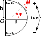
(2010-10-14) Geodetic Reference System (GRS-1980)
Defining the geodetic latitude (j),
longitude (q) and elevation (h) of M.
The so-called Geoid is essentially the mean sea level
surface of the Earth. Irregularities in the gravitational field of the Earth
(due to irregularities in its mass distribution) make the actual Geoid a
very complicated surface...
To a very good approximation, that irregular Geoid
matches the shape of a perfect spheroid, standardized by the IUGG in 1980
(and known as the Reference Ellipsoid):
Equatorial radius a = 6378137 m
Polar radius b = 6356752.3141 m
The meridian of that surface at any longitude
q is a half-ellipse where a point is identified by
its [geodetic] latitude
j, which is defined as the angle from the equator to the
upward geodetic vertical
(itself defined to be perpendicular
to the surface of the spheroid, it is virtually indistinguishable
from the direction of a plumb line).
At zero longitude (y = 0) the cartesian equation of the meridian is:
(x/a) 2 + (z/b) 2 = 1
Differentiating that equation or writing that
(cos j, sin j)
is perpendicular to (dx,dz) we obtain two separate relations,
which must be proportional:
(x / a 2 ) dx + (z / b 2 ) dz = 0
and
cos j dx
+
sin j dz = 0
Calling Rj the coefficient of
proportionality between them, we have:
x = (a2 / Rj )
cos j
and
z = (b2 / Rj )
sin j
Plugging those two values into the above equation of the ellipse, we obtain:
Rj2 =
a2 cos2 j
+
b2 sin2 j
The coordinates of a point of nonzero elevation h
(along the geodetic vertical)
are obtained by adding the following corrections to the above:
Dx = h cos j
and
Dz = h sin j
So, the conversion formulas
from geodetic to 3D cartesian coordinates are:
Cartesian coordinates of a point of elevation h
at [ geodetic ] latitude
j
and longitude q :
x =
( a 2/ Rj + h )
cos j
cos q
y =
( a 2/ Rj + h )
cos j
sin q
z =
( b 2/ Rj + h )
sin j
where Rj2 =
a2 cos2 j
+
b2 sin2 j
As shown below, the quantity
Rj can be given the following
differential characterization, in terms of the distance
r to the center of the Earth:
(2011-06-28) Geocentric Coordinates
Geocentric latitude (j0 )
is almost never used...
Only the above geodetic coordinates are used in geography.
Geocentric coordinates are all but useless, except as
approximations in physics.
The geocentric latitude of a point (at elevation h = 0)
on the surface of the Earth is the angle between the plane of the equator and the
radius vector originating from the center of the Earth.
That unused flavor of latitude is denoted by
j0.
At q = 0, its tangent is z/x, which yields:
tg j0
=
( b 2/ a 2 )
tg j
Numerically:
tg j0
=
0.99330562 tg j
(2011-06-28) Radius of the Earth at a given latitude
j.
Distance to the center of a point located at the surface of the Earth.
The actual distance r
of a point to the center of the Earth is given by:
r2 =
x2 + y2 + z2 =
( a 2/ Rj + h ) 2
cos2 j +
( b 2/ Rj + h ) 2
sin2 j
=
(Rj4
-
2 a2b2
sin2 j cos2 j )
/ Rj2
+
2 h Rj + h2 =
(Rj + h) 2
-
2 (a b
sin j cos j
/ Rj ) 2
Although
Mount Everest is
the peak of highest elevation
(h = 8848 m) its distance to the center of the Earth
(r = 6382.3 km)
is about 2 km less than the record
(r = 6384.4 km)
achieved at the top of the
Chimborazo volcano
in Ecuador (h = 6268 m).
Nevado Huascarán
in Yungay (Peru) is a close second
(by only 18 m).
Distances to the center of the Earth of some famous peaks :
The top of Mont Blanc is actually at the same distance from the center
of the Earth as a point 6148 m below sea-level at the equator.
The radius of a sphere having the same volume as the reference ellipsoid is:
(a2b) 1/3 = 6371000.79 m
The rounded value R = 6371 km
is the conventional radius of the Earth.
It's the distance from the center of the Earth to the surface of the ocean
at a latitude of 35.402807°.
The top of Mont Blanc is just 989 m further out.
Jennifer Bishop
(Wake Forest, NC. 2004-05-21; e-mail)
What is the volume of the Grand Canyon?
Only a rough number can be given, since the object itself is
not even precisely defined geometrically.
Here's the data on which we may base an estimate:
Length (from Lees Ferry to the Grand Wash) : 277 miles
Average width (rim-to-rim) : 10 miles.
Average height of rims above the river: 1 mile.
Taking these numbers at face value, we obtain a volume of 2770 cubic miles.
Considering that this is probably an overestimate (the walls are not vertical, etc.)
and that three significant digits would be a misleading representation of the
precision thus obtained, we should probably state that the volume of the Grand Canyon is
about 2500 cubic miles or around:
1013 m3
This corresponds to about 80% of the volume of Lake Superior or 40% the volume of
Lake Baikal (Siberia) and would represent a thickness of around 3/4" (2 cm)
if spread over the entire surface of the Earth.
(2003-11-01)
What is the oldest city in the World?
Among the contenders below,
the title should probably go to Jericho...
Jericho, "West Bank"
A green oasis in the Jordan Valley, 20 km east of modern Jerusalem
(7 km west of the Jordan River and 10 km north of the Dead Sea)
Jericho lies 250 m below sea level.
It's the lowest major city in the world and one of the oldest
continuously inhabited places, with vestiges dating back to about 9000 BC;
s few short centuries after the end of the
Last Glacial Period
(c.9550 BC) at a time when the last
woolly mammouths were still
roaming Northern latitudes.
Pottery didn't exist yet and writing wouldn't appear for thaousands of years.
It was the first human settlement to be surrounded by protective walls
(of biblical fame)
with the first known tower.
Jericho provides the first evidence of communal labor
in a group of people not limited to a single clan.
This is arguably the place where animals were first domesticated
and wide-scale agriculture was born.
Damascus, capital of Syria
Also known as Al-Sham or Dimashq, Damascus is on record as the capital of
an Aramaean kingdom conquered by the Assyrians in 732 BC.
According to ancient Egyptian manuscripts, it was already the capital of a small
Aramaean principality as early as the 15th century BC.
The area may have been settled as early as 6000 BC,
or even 8000 BC, a millenium or so after Jericho.
Kerma (or Karmah) capital of ancient Nubia
Karmah an Nuzul is a town of modern Sudan, built on the ruins of
the capital of a kingdom which once rivaled the contemporary achievements
of ancient Egypt.
Nubia is a region of Black Africa surrounding the Nile valley,
between present-day Karthoum (Sudan) and Aswan (Egypt).
Egyptian and Nubian civilizations may have borrowed heavily from each
other, but they were once clearly distinct.
Ceramics were found in Nubia dating back to 8000 BC which may
predate equivalent "Egyptian" achievements
("Egypt" was politically unified by the first pharaohs,
around 3100 BC).
The urban ruins at Karmah seem to be the most ancient on the
African continent.
The region was known as "Kush" to the ancient Egyptians, but this term is
now best reserved to a more recent kingdom (capital: Napata)
which regained its independence from Egypt around 850 BC and
went on to conquer and reunite all Egyptian principalities,
around 750 BC.
Egypt's "25th Dynasty" thus consisted of Kushite pharaohs who were perceived
as foreigners. They did not lose control of Egypt until Assyrians invaded
the country, almost a century later (674-663 BC).
The earliest settlers of Kerma seem unrelated to the Badarians
who are
apparently,
the direct ancestors of the ancient Egyptians.
The Predynastic Period of "Egypt" is often divided into 3 parts, named after
archaeological sites: Badarian (Tasian), Amratian (Naqada I),
and Gerzean (Naqada II).
The stone-age Badarian culture existed as early as 4400 BC
or, possibly, 5000 BC.
Rome, capital of Italy
According to its own legend, the "Eternal City" was only founded in 754 BC.
Teotihuacán, pre-Columbian central Mexico
This is the great archeological site which contains the ruins of the oldest
city in the Americas.
Teotihuacan means "City of the Gods" in
Nahuatl.
It was probably founded around 300 BC and became prominent before
the beginning of the Christian era.
At its peak, around AD 500, the city was home to about 200 000 people,
surpassing what would be the size of Shakespeare's London,
a millenium later.
By AD 700, Teotihuacan had been sacked and burned
(most probably by Toltec invaders), but its regime had lasted longer
than the Roman Empire.
Teotihuacan's principal axis, the Avenue of the Dead,
is dominated by one of the largest monuments of the ancient world,
the 65 m Pyramid of the Sun (completed before 150 BC).